


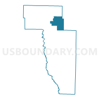
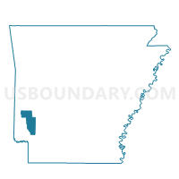
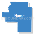
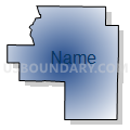
CLAY Voting District, Howard County, Arkansas
About
Outline

Summary
| Unique Area Identifier | 526649 |
| Name | CLAY Voting District |
| County | Howard County |
| State | Arkansas |
| Area (square miles) | 27.68 |
| Land Area (square miles) | 27.65 |
| Water Area (square miles) | 0.03 |
| % of Land Area | 99.90 |
| % of Water Area | 0.10 |
| Latitude of the Internal Point | 34.23216160 |
| Longtitude of the Internal Point | -93.96373730 |
Maps

Graphs
Select a template below for downloading or customizing gragh for CLAY Voting District, Howard County, Arkansas


Neighbors
Neighoring Voting District (by Name) Neighboring Voting District on the Map
- BLUE RIDGE Voting District, Howard County, AR
- BURG Voting District, Howard County, AR
- HOLLY CREEK Voting District, Howard County, AR
- Langley/Lodi Voting District, Pike County, AR
- MOUNTAIN Voting District, Howard County, AR
- New Hope Voting District, Pike County, AR
- UMPIRE Voting District, Howard County, AR
Top 10 Neighboring County Subdivision (by Population) Neighboring County Subdivision on the Map
- White township, Pike County, AR (618)
- Mountain township, Howard County, AR (388)
- Umpire township, Howard County, AR (251)
- Mountain township, Pike County, AR (249)
- Holly Creek township, Howard County, AR (219)
- Blue Ridge township, Howard County, AR (193)
- Clay township, Howard County, AR (155)
- Burg township, Howard County, AR (61)
Top 10 Neighboring Unified School District (by Population) Neighboring Unified School District on the Map
- Nashville School District, AR (9,494)
- Wickes School District, AR (3,273)
- Dierks School District, AR (2,915)